Driving Restrictions Australia
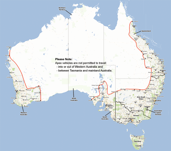
The map on this page shows the inland boundary where you are permitted to drive Apex vehicles. If vehicles are driven beyond the boundary line they will not be covered by insurance and the renter will be responsible for any recovery costs.
The boundary runs from the northern-most point, Cooktown in far north Queensland, down State Route 81 south to Mareeba. It then follows National Route 1 from Mareeba through Atherton and southwest to Minamoolka. At Minamoolka the road continues south on State Route 62 (also known as the Kennedy Developmental Road) to the turn off to Conjuboy and then heads southeast on State Route 63 (also known as Gregory Developmental Road) through to Charter Towers.
From Charter Towers you continue south along National Highway A7 (Gregory Hwy) to Emerald. From Emerald the boundary line takes you east towards the coast on National Highway A4 and passes through the towns of Blackwater, Dingo, Duaringa, and Gogango. Approximately 10kms after Gogango the boundary heads south again and follows National Highway A5 to the town of Dululu. Alternatively you can continue on the Gregory Hwy to Rolleston then follow Route 60 (Dawson Hwy) to Banana.
From Rolleston you may head south on the Carnarvon Hwy to Roma, afterwards heading back east on the A2 towards Miles.
Leaving Dululu the boundary follows National Highway A5 to Banana and continues south to Miles. From Miles you can continue on the A5 heading south towards Goondiwindi passing through Condamine and Moonie until you reach Goondiwindi.
From Goondiwindi you continue on National Highway 39 south through Moree, Narabri, and Coonabarabran, until you reach Dubbo. From Dubbo you can head inland on National Highway 32 through Nyngan, Cobar, Willcania, on to Broken Hill. Continue on National Highway 39 heading southwest until you reach the turn-off for Peterborough and then follow National Highway B56.
National Highway B56 takes you through Peterborough and then north to Black Rock. From Black Rock you follow National Highway B80 north to Orroroo and on through Eurelia, Carrieton, and Craddock before joining National Highway B83 heading north to Marree which is the northern most you may travel. From Marree you can take the road south on the B83 to Port Augusta.
From Port Augusta head north on the A87 towards Pimba then onto the B97 to Roxby Downs, this route must be followed to return to Port Augusta also.
The western boundary is defined by Kyancutta on National Highway 1 and the town of Elliston, where National Highway B91 joins with National Highway B100 along the south coast. Drivers are not permitted to travel on the Kyancutta-Mount Wedge Rd as it is not safe. If wanting to travel to Elliston you must travel via the B90 to Lock and then head west on the B91 to Elliston.
Tasmania also has special restrictions, with no cars permitted to travel across Bass Strait from the mainland or vice versa.
Western Australia has its own boundaries as rentals from Perth are not permitted to leave Western Australia. Boundaries for Western Australia start from the furthest northern point at Exmouth, from Exmouth head South on Murat Rd, continue heading south until connecting with Minilya-Exmouth Rd. Minilya-Exmouth Rd will continue until arriving at Minilya. From Minilyatravellers may only turn right and head South on North West Coastal Hwy 1 to Carnarvon. Upon reaching Carnarvon follow the National Hwy 1 down to Geraldton. From Geraldton you can take State Route 123 out to Mount Magnet. From Mount Magnet follow National Hwy 95 south to Wubin. From Wubin you may take State Route 115 to Northam or continue on National Hwy 95 to Perth.
From Northam follow National Hwy 94 East Coolgardie, from Coolgardie take the National Route 94 alternative Road to Kalgoorlie. From Kalgoorlie follow the Goldfields Hwy south to meet back up with National Hwy 94. Continue heading south on National Hwy 94 to Norsemanuntil meeting back up with National Route 1. The boundary then continues south until reaching Esperance.
From Esperance follow National Route 1 back to Perth there are no other boundary restrictions heading back west towards Perth.
Under no circumstances can Apex vehicles be driven to Western Australia or the Northern Territory.
Geographical Restrictions Map
Apex vehicles may only be used within a defined geographical area marked on the map below.
Please hover over the map to zoom in.